Missoula County, Montana 1921
Missoula, the name both of the county
and its seat of government, is one of the most musical words of
the Salish tongue connected with the Indian nomenclature of
Montana. It is derived from the native In-missou-let-ka, the
English translation of which is "The River of Awe." The phrase
especially refers to the River Missoula, the waters of which
gathered from five great valleys pour and dash through the
beautiful city of Missoula and might well strike awe into the
sensibilities of the modern human, to say nothing of the
primitive Indian who had greater leisure than the man of today
to consider its grand and ever shifting movements.
County of the Five Valleys
Not all of the counties of Montana
are so favored as is Missoula, nor have all of them the natural
resources of this county, which allow its people a choice of
various occupations. Located midway between the north and south
boundaries of Western Montana, it has been known as "the County
of the Five Valleys," and of these five all are productive. The
Bitter Root Valley long has been known because of the fine
quality of its apples ; the Blackfoot Valley is noted for its
livestock and wheat; the Flathead Valley is one of the best
farming districts in the state for diversified agriculture; the
Missoula Valley raises thousands of tons of hay and grains
annually, and the Flint Creek Valley is a producer of
agricultural crops of all kinds.
Missoula County is practically square
in size, being fifty-five miles long from north to south and
fifty miles wide from east to west, and all of the county is in
a mountainous region, with the Flathead Valley in the northwest
section, comprising about 210,000 acres of agricultural land,
mostly irrigated and rolling country. The Missoula and Grass
valleys, situated in the central part of the county, are
irrigated and agricultural comprising 70,000 acres. The Bitter
Root Valley, in the south central part, and the Blackfoot Valley
in the east central district are narrow and fertile, that part
of the former in Missoula County containing about 20,000 acres,
and of the latter 25,000 acres.
Lumbering
Naturally Missoula County is largely
agricultural and hay and grain are among some of the principal
crops, while much fruit is raised. Timothy and clover are raised
all over the county and in some parts of the Flathead Valley
alfalfa is a principal crop. But while agriculture has a leading
place among the industries, another of perhaps equal importance
is lumbering, the total amount cut annually for the county being
approximately 150,000,000 feet. The timber lands of the county
are very extensive, and the eastern half and southwest portion
of the county are almost solid timber land. Pine, fir and
tamarack are the chief species. The Anaconda Copper Mining
Company has one of the largest and most up-to-date mills in the
Northwest, at Bonner, seven miles east of Missoula, the annual
capacity being 100,000,000 feet. The Western Lumber Company also
has a large mill at Milltown, with a capacity of 25,000,000
feet, and Polleys Lumber Company has a plant at Missoula with a
capacity of 20,000,000 feet. There are several other plants
which have a combined capacity of 5,000,000 feet, and logging
camps are located in all parts of the county. Blooded stock
raising is a growing industry, and other enterprises which are
thriving are several woodworking plants, and a manufacturing
plant at Missoula City the output of which consists of culverts
and flumes.
Drainage and Water Supply Missoula
County is splendidly provided for, as to drainage and water
supply. The sources of water supply for all irrigation purposes
are from the many mountain streams fed by snow and glaciers. The
principal stream is the Missoula (or Hell Gate) River, from
which the county derives its name, which enters the county at
the extreme southeastern corner and follows a northwesterly
course for its entire width. The Missoula River is fed by the
Blackfoot River east and the Bitter Root River which runs north
and south, four miles west of Missoula. The Jocko River, which
runs westerly through the central part of the county, supplies
the United States reclamation projects for the lower part of the
Mat head. The Clearwater River runs from the extreme north end
of the county in a southerly direction for about forty miles,
where it empties into the Blackfoot and both the Blackfoot and
Clearwater are noted as fishing streams. The Rattlesnake Creek
is the source of water supply for Missoula City and is one of
the finest streams in the Northwest for domestic purposes.
Government tests and analyses have shown the water of this
stream to be chemically pure. In rural districts the domestic
water supply is from wells and from natural springs developed
into gravity systems for community use.
Evolution of Missoula County
Missoula County antedated the
territory several years. In December, 1860, the Legislature of
Washington Territory divided the County of Spokane and created
the County of Missoula, with the county seat at or near the
trading post of Worden & Company, at Hell Gate Ronde It then
embraced all those portions of the present counties of Missoula
and Deer Lodge lying west of the main range of the Rocky
Mountains. Missoula County remained a portion of Washington
Territory until Idaho Territory was organized on the 3rd day of
March, 1863, when it became a portion of the latter. On the 26th
of May, 1864, Congress created Montana Territory and the first
Assembly, which met at Bannack, in February, 1865, located the
county seat at Hell Gate. To attain its present form, parts were
taken from Missoula County, in 1893, to form Flathead and
Ravalli counties and to add to Sanders, in 1906, and Mineral, in
1914; while a part of Powell County was annexed to Eastern
Missoula County in 1915.
Missoula County is well settled,
being the fifth in population of the Montana counties. The
census of 1920 gives it 24,041, as compared with 23,596 in 1910.
Of the county total, the city itself has 12,668. The average
value of improved irrigated land ranges from $65 to $125 per
acre, and improved non-irrigated land is valued at from $45 to
$65 per acre. Small improved tracts adjacent to towns sell at
from $350 to $700 per acre. Non-improved cultivable lands,
grazing lands, sell for approximately $25 per acre. There are
three National Forests in the county, Lolo, Lewis and Clark and
Missoula.
Missoula County enjoys the benefits
of a modern, up-to-date school system. There are sixty-three
public schools, three parochial and one Americanization night
school, and in the city of Missoula City alone there are ten
grammar schools and one county high school. Many of the rural
schools have been consolidated and numerous motor busses are
used to transport the children to and from the school buildings.
In addition to the University of Montana, Missoula City has a
first class business College.
Highways, Scenery and Tourists' Trips
Two transcontinental railroad lines,
the Chicago, Milwaukee & St. Paul, electrified, and the Northern
Pacific, traverse the county, the latter having a divisional
terminal here. Local daily trains are made up at Missoula and
operated to the Bitter Root Valley, to Hell Gate Valley, Grass
Valley, the Coeur d'Alene and the Flathead. There are also, in
summer, many automobile stages to each of these valleys. One
electric line runs from Missoula to Bonner, seven miles distant,
and the principal state highways are the Yellowstone Trail and
the National Parks Highway. Hunting and fishing are to be
enjoyed all along the main traveled highways, and ideal natural
camping grounds along good streams are available in all
sections. The Mission range of mountains, in the Flathead
Valley, with its glaciers and lakes, is unsurpassed for scenery.
The Bitter Root, Blackfoot and Flathead Valleys also possess
wonderful scenery, and visitors in this vicinity are generally
directed to visit Lolo Hot Springs, and Salmon and Seely lakes.
Automobile tourists who pass through the county will find ideal
camping grounds provided for them by the Missoula Chamber of
Commerce in the City of Missoula. A trip that finds much favor
among the tourists in this region is that of the Western Montana
Park-to-Park Highway Route. Leaving the western gateway of the
Yellowstone, the trail enters a scenic wilderness where arise
the extreme headwaters of the Missouri River. Deer and elk are
found in the hills, and the fisherman finds his labors well
rewarded. The road follows the Centennial Valley along the
Bitter Root Mountains into Monida, where the Oregon Short Line
and the principal road to Salt Lake City are met. The line of
the railroad is kept to Armstead, where the beautiful memorial
to Sacajawea, in honor of the squaw who piloted Lewis and Clark,
has been erected by Montana women. From Armstead the way leads
to Dillon, where is situated the State Normal College. Bannack,
the first capital of Montana and the scene of early gold
discoveries and of many of the most important events in the
state's history, lies just beyond. Hangman's Gulch, where the
Vigilantes rid the state of several bandits, is near Bannack and
on the trail. Here begins the fertile Big Hole Valley, rich in
soil and possessed of natural charms. Near Wisdom, farther on,
is the Gibbon battlefield, the scene of the defeat and downfall
of Chief Joseph and his hardy band of Nez Perces. From Wisdom
across the Continental Divide into the Bitter Root Valley, the
local governments and the United States Forest Service together
built a scenic road. It follows an easy grade through the
mountains and leads at last into the Bitter Root at Medicine Hot
Springs. Thence the highway runs straight down the valley to
Missoula. From Missoula the road runs across the former Flathead
Indian Reservation, skirts the bison reserve where buffalo still
range,1 and penetrates the land of the Salish, peace-loving
Indians who still live in their native picturesqueness. The
Flathead's wide prairies have been thrown open to settlement and
white farmers have made the land blossom beside the tepee
villages of the red man. The highway then runs along the banks
of Flathead Lake to Kalispell and thence through an attractive
country to the gateway of Glacier Park.
The City of the Five
Valleys
Missoula, the county seat of Missoula
County, is known both as "Montana's Garden City," and as "The
Fine Little City in a Fine Big Country," likewise as "The City
of the Five Valleys." It had its inception in 1865, when two
traders, Frank L. Worden and Christopher P. Higgins, who had
built a post at "Old Hell Gate," five miles west of the present
city of Missoula, reached the conclusion that their business
could be transacted to better advantage at the meeting point of
Rattlesnake Creek and Hell Gate River, and accordingly laid the
cornerstone for the present city of more than 12,000 people. The
city was incorporated in 1883, reincorporated in 1887 under the
general laws, and in 19 17 adopted the commission form of
government of three men, a mayor and two commissioners.
Missoula lies at an altitude of 3,223
feet above the sea level, which, while not too high, insures a
cool, dry, health-giving climate. During the summer the nights
are cool, with breezes descending upon the valley from the
snow-capped mountain peaks. The winters, while seldom severe,
afford enjoyment to the cold-weather sportsman, permitting
sleighing and skating during a considerable season. The average
annual rainfall is 15.5 inches.
By reason of its location and natural
advantages, Missoula is one of the important mercantile and
manufacturing centers of the Northwest and is a leading
financial, industrial, wholesale, commercial and railroad
distributing point for Western Montana. One of the factories of
the Great Western Sugar Company has made its home at Missoula,
constructing a plant there which cost $1,500,000. From 400 to
600 employees work in the plant, which forms an incentive to the
best sugar growers of this region. The creamery at Missoula has
a daily output of 2,000 pounds of butter, and other important
industries include a flour mill, a sash and door factory, a
potato chip factory, vinegar and cider factories, two brick and
tile plants, book binding and book making plants, and a
lithographing establishment doing work for firms throughout the
Northwest. There are three live and progressive newspapers.
Missoula is a well-governed and
well-conducted modern city and its conveniences and utilities
compare favorably with large cities throughout the country. For
the most part, the residence streets are either boulevarded or
parked and there are several miles of paved streets, more than
100 miles of cement walk and more than twenty miles of street
railway service track. Electricity for lighting and power is
obtained from a power plant seven miles east of the city, where
approximately 25,000 horse-power can be produced. Practically
all the buildings in the business section of the city are heated
by steam from a central plant, and a gas plant furnishes that
commodity to those who prefer its use. The water supply has been
chemically proven among the purest in Montana, and is handled by
a gravity system. The city maintains a strict sanitary
inspection, extending to all food-stuffs which are sold, and
rigid dairy inspection.
Architecturally, Missoula is one of
the handsomest cities of the state. The Montana Building was
erected at a cost of $120,000, the Federal Building $175,000,
and the courthouse, one of the finest in Montana, $250,000.
Among the fraternal orders the Elks' Temple, Masonic Temple and
the homes of the Knights of Pythias and the Odd Fellows are
handsome edifices. The Missoula Chamber of Commerce, a
well-organized and energetic body of which D. D. Richards is
secretary, owns its own home, a structure valued at $30,000. The
city likewise has four strong banking institutions.
Greenough Park, lying in the
northwestern part of the city, is a natural playground in which
Rattlesnake Creek takes its tumbling, crystal course through the
midst of virgin woodland which has been cultivated only in so
far as to remove the underbrush. Sacajawea Park, in the
southwestern part of the city, has become a pleasing reality
through the efforts of the Missoula Women's Club, and another
park in Hammond Division, presented to the city by the South
Missoula Land Company, has been developed and adds its
attractions. The Milwaukee Railroad has reclaimed the south bank
of the river in the vicinity of its station, making it a
beautiful little park, approached by rustic bridges, and the
Northern Pacific Railroad, by parking and installing an artistic
fountain and statue of Capt. John Mullan, has made the vicinity
of the station extremely attractive. Missoula's theater-goers
enjoy some of the best productions staged.
Missoula offers to its residents the
benefits of a Free Public Library, which was founded in 1894 by
the Library Association, and endowed in 1902 by Andrew Carnegie.
In 1917 there was added the county library department, available
to all residents of Missoula County, the second of its kind to
begin operations in Montana and the first to be operated in
connection with an old establishment. There are five branches,
two located in the public schools at Ronan and St. Ignatius, two
in the stores at Frenchtown and Potomac, and one in a private
home at Carlton. In addition to this branch system, the library
serves its out-of-town patrons through the parcel post, the
sending charges for which the library pays. The collection now
contains 20,116 volumes, and Mrs. Grace M. Stoddard is
librarian. The institution is under the supervision of a
governing board of trustees, appointed by the city council.
Missoula has three hospitals, the
Northern Pacific and St. Patrick's, and the hospital at the
County Poor Farm, which is located three miles northeast of the
city. In the city is located a well-organized Young Women's
Christian Association, of which Mrs. E. E. Kinsman is secretary;
the executive office of the Missoula, Ravalli and Sanders
Counties Medical Society, of which Dr. J. J. Tobinski is
secretary-treasurer ; and the Western Montana Fair Association,
of which F. P. Keith is president. The office of the state
orchard inspector is located at Missoula, and from this office
there is a rigid prohibition maintained against the importation
of infected fruit. This is necessary, as the region is an
excellent fruit country for the growing of pears, plums,
cherries, crabapples and strawberries, particularly in the
Rattlesnake Valley, which begins to the northeast of Missoula,
twenty-five miles distant, and which was thrown open to
settlement in 1909. The winter in this region is moderated by
the Chinook, or warm Pacific coast wind, which has a salutary
effect upon the growing fruit.
In the thirteen churches of Missoula,
nearly every denomination is represented. The credit for
building the first church in the city is given to Dr. Thomas
Corwin Iliff, who located at Missoula in 1871, and September 15,
1872, dedicated the Methodist Episcopal Church, which was
attended by people of all denominations. Prior to this, as early
as 1863, Father Grassi had built a log church about six miles
below Missoula, three-quarters of a mile beyond the old Town of
Hell Gate, which later became the Catholic Church of St. Francis
Xavier, and a little later he and Father Menetry erected another
at Frenchtown. These two churches were erected many years before
a church was built at Missoula, but it was not until December
11, 1881, that the first Catholic Church was opened for service
within the city limits, Rev. Joseph Menetry being the pastor.
St. Francis Xavier Catholic Church is now housed in an edifice
which was dedicated on October 9, 1892. A Presbyterian Church
was organized in 1877, and the Christian and Baptist (Immanuel)
churches followed in 1884. The first Methodist Episcopal was
formed at an early day, the Swedish Congregational and the
Swedish Evangelical Lutheran (Immanuel) were founded in the
'90s, and the Protestant Episcopal, Church of Christ
(Scientist), Trinity Methodist Episcopal, African Methodist
Episcopal and others were established at a still later date. In
1916 the Presbyterian and the Congregational churches at
Missoula united.
Educational System
Missoula has reason to be proud of its educational system which
provides ten grammar schools and the Missoula County High
School, while the city is likewise the home of the State
University, of Montana's College of Arts and Sciences, and
Schools of Business Administration, Forestry, Journalism, Law,
Music and Pharmacy. The Roman Catholic denomination provides for
St. Joseph's School, the Sacred Heart Academy and Loyola High
School. The grammar schools are distributed in various parts of
the city so that every child is within easy walking distance of
his place of educational training, Hawthorne, Franklin, Willard
and Roosevelt schools are situated on the south side of the
city, while Central, Prescott, Lincoln and the City Manual
Training buildings are in the eastern part, and Whittier and
Lowell on the north side. The manual training building also
provides for the city's domestic science department and is well
equipped for both subjects. Every one of the ten schools has a
commodious playground, and the schools are presided over by the
city superintendent. They also have a supervisor of music and
one of drawing, and a large corps of competent teachers is
employed. Within the county borders there are thirty-nine school
districts and most of the districts maintain standard schools.
The Catholic school system is an
excellent one, in which St. Joseph's School, for boys under the
high school age, and Sacred Heart Academy, for girls, are
presided over by the Catholic Sisters. Some of the students of
these institutions are from Wyoming and Idaho, but 50 per cent
are residents of Missoula. The two schools have an excellent
playground. Loyola High School, the Catholic school for boys, is
conducted by the Fathers of the Society of Jesus. The Missoula
County High School is the best equipped secondary school in
Western Montana, and the present buildings represent an outlay
of $150,000. For nearly ten years the high school has maintained
a manual training department in which the boys are taught
mechanical drawing, drafting, architecture, topographical
drawing, etc.; and a domestic science department, in which the
girls are taught costume designing, dressmaking, cooking,
dietetics, household management and household decoration. The
commercial department is well organized and has been a regular
part of the school curriculum for eight or nine years.
State University
While the first years in the life of
the University of Montana, which was created by an act of the
State Legislature in 1893, were ones of hardship, the
institution today holds place among the best of the western
universities. For the four years of its infancy the institution
held its classes in the rooms of one of the city public schools,
under Oscar J. Craig, the first president, and his four
associates, but in 1897 the Legislature issued bonds to the
amount of $100,000 for two buildings, and two Missoula residents
donated the present campus site which includes forty acres at
the foot of the mountains which enclose the eastern end of the
valley, and 520 acres on the slopes of Mount Sentinel. This
mountain rises abruptly 2,000 feet above the plain. Today the
university has five large and well-equipped buildings, as well
as other structures of a temporary character which will be
replaced in the future with larger and more substantial
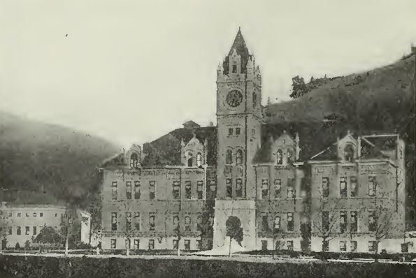
buildings. University Hall is the administration building in
which are also located the assembly hall of the university and
classrooms, lecture rooms and laboratories. Science Hall is
occupied by the School of Pharmacy and the Department of
Chemistry. Natural Science Hall, which was completed in January,
1919, is a modern, three-story laboratory building, containing
the classrooms and laboratories of the departments of biology,
botany, home economics and physics, as well as a large lecture
room, equipped with stereopticon and motion picture apparatus.
Craig Hall is the women's dormitory, entirely used as a domicile
for the women students of the institution. The gymnasium is
equipped for the physical education of all students, and
adjoining it is Dornblaser field, the athletic ground, with its
stands and tracks. Library Hall contains the university library,
the law library, the classrooms of the School of Law and other
lecture and classrooms. The Forestry and Music buildings are
frame structures, affording temporary quarters for these
schools. The hospital is designed for the isolation and
treatment of students who may be suffering from contagious or
infectious diseases. Simpkins Hall and Cook Hall are the
buildings erected for barracks. They were remodeled so that the
former serves as a men's dormitory and the latter is the armory
of the R. O. T. C. and temporary quarters of the School of
Journalism.
State University, Montana
President Craig remained at the head
of the university until 1908, when failing health compelled his
resignation. He was succeeded by Clyde A. Duniway, who came to
Montana from Stanford University. During the administration of
President Duniway, the summer session was inaugurated and the
School of Law established. In 1912, Edwin Boone Craighead, of
Tulane University, succeeded President Duniway. He continued in
office until 1915, and under his presidency the schools of
Journalism and Forestry were established, the School of Pharmacy
reorganized, and the departments of Business Administration and
of Domestic Science were added to the College of Arts and
Sciences. In 191 5, Prof. Frederick G. Scheuch was appointed
acting president and continued in that capacity until the summer
of 1917. Edward O. Sisson was appointed president of the
university in 1917, coming to Montana from Idaho, where he had
held the office of state commissioner of education. In July,
1921, Doctor Sisson was succeeded by Dr. Charles H. Clapp,
former president of the Montana State School of Mines.
Missionary Work of the Railways
Missoula is situated in the midst of
a rich tributary country, being located in the one logical spot
for a city where the five valleys came together. In the '80s,
during the construction of the Northern Pacific Railway, the
directors of that line sent out prospecting parties to examine
all the passes through the mountain ranges of Western Montana.
It was natural that they should wish as direct a route as
possible from Butte to the Pacific coast, but the preliminary
surveyors were left no choice in the matter. They found that
there was but one way open to the railroad, that being to follow
the lead, of the Indian tribes, of the Lewis and Clark
expedition and of the Mullan Military Highway, and swing north
down the Hell Gate River and through Hell Gate Canyon, at the
mouth of which the little town of Missoula had been already
established. Later, several railroads endeavored to pierce the
mountains in some other place, but failed, and in 1907 the
Chicago, Milwaukee & St. Paul found its only course to pursue,
that of paralleling the Northern Pacific, Missoula thus securing
its second transcontinental railway.
In traversing this region, the
railways have found that they go through a rich region. The Hell
Gate River formed two valleys from which they could draw upon
the Hell Gate Valley above Missoula and the broad Frenchtown
plains below the city. A few miles to the east of Missoula, the
Blackfoot River joins the Hell Gate, making its immense drainage
basin tributary to the city and south from the city itself for
ninety miles lies the rich valley of the Bitter Root River. A
few miles to the west of Missoula, on the other side of a low
pass which the Northern Pacific crosses, the broad expanse of
the Flathead Valley stretches northward forty miles from the
railway to Flathead Lake. The Bitter Root and Frenchtown valleys
were sparsely settled when the Northern Pacific first came
through Missoula, but it was not until the advent of railway
transportation that the development of this part of the state
really had its beginning. In those days, when Montana had just
been granted statehood, nearly all of Western Montana was
included in the one County of Missoula. The rapid growth 'of
this region can be demonstrated in no better way than to make
note of the fact that instead of one county, this territory now
includes five counties within its borders. As the valleys
increased in wealth and population, they dropped away from the
mother county and set up governments of their own, but Missoula
still remains the richest and most populous of them all, for it
contains the central point from which they all radiate.
Development of the Valleys
Included in the Hell Gate Valley is
the district along the Hell Gate River from Garrison to
Missoula, a distance of seventy miles. The valley varies from a
narrow canyon with hardly room for the railway tracks to a width
of six or eight miles. At Drummond, forty miles from Missoula,
the Flint Creek Valley branches off to the south, and in it are
the rich farm lands and mines of Granite County. Agriculture,
lumbering and mining form the principal industries of Hell Gate
Valley, and primitive mountain scenery greets the eye on either
side, a scenery made more inviting by the fishing and big game
hunting which are included with it. The valley is provided well
with railways and highways, both the Northern Pacific and the
Chicago, Milwaukee & St. Paul railways traversing its entire
length, while at the present time automobile traffic is
prolific, coming over the National Parks Highway and the
Yellowstone Trail. Chief among the numerous small towns that dot
the valley are Garrison, Drummond, Bearmouth, Gold Creek, Bonita
and Clinton.
The Blackfoot Valley, the development
of which is a matter of comparatively recent date, comes into
Missoula from the northeast. The Anaconda Copper Mining Company
built the first railway up the valley in 1911 as a logging road
to keep its Bonner sawmills supplied, and later the Chicago,
Milwaukee & St. Paul took over the road and completed it to
Potomac. This has now been graded to Ovando, a distance of sixty
miles from Missoula, although the valley extends some thirty
miles beyond that point. While there had been some ranches in
the valley prior to the coming of the railway, that innovation
held out a greater inducement and was the means of attracting
numerous homesteaders. Grain ranches, stock farms and large
grazing lands are the principal assets of the country included
in the valley, where there are also magnificent forests. The
beautiful lake regions and the fishing of the Blackfoot Valley
attract many summer visitors, an increasing number of whom have
established regular camps, a regulation of the forest service
providing that five-acre tracts may be taken over by an
individual for this purpose. In the autumn months hunters flock
to this region. The larger of the towns include Bonner,
McNamara's Landing, Lincoln, Sunset, Potomac, Clearwater, Ovando
and Helmville. Bonner is a lumbering center, seven miles east of
Missoula.
Extending for thirty miles along the
Hell Gate River, west of Missoula, is the Frenchtown Valley, an
old and established community which dates its settlement from
1860, when Jesuit priests set up a mission at Frenchtown. The
valley is naturally almost free from timber, the land is gently
rolling, and geologists explain the openness and flatness of the
whole region by stating that it was once the bottom of a huge
lake. As is the case with other valleys around Missoula, the
Frenchtown district is well supplied with transportation
facilities, both of Missoula's transcontinental railways
extending through it, the main branch of the Milwaukee, and the
Coeur d'Alene branch of the Northern Pacific. Numerous
automobile roads extending through the valley are kept in the
best of condition. The name "Grass Valley" formerly applied to
the Frenchtown district indicates the product it is especially
adapted to, which makes it an excellent livestock country.
Hereford cattle from the Deschamps ranch of this county have
frequently topped the Chicago market. Grain raising is also
becoming an important industry, and most of the crops in the
valley proper are under irrigation, although dry land farmers
are getting good results from their methods of cultivating the
more gentle rolling foothills. Frenchtown, from which the valley
takes its name, is the chief town.
There has been in existence for some
years the idea that the Bitter Root Valley was settled by
General Price's left wing, such an impression having been
founded on the remark of a veteran of the Civil war. In fact,
the date of its settlement goes even back of the war between the
states many years, for it was in 184 1 that Father DeSmet
invaded the valley and founded St. Mary's Mission, near the
present community of Stevensville, and since then the sunny
climate of the Bitter Root and the fertility of its soil have
led to its becoming one of the most populous valleys of the
state. The richness of the Bitter Root was early recognized by
the Northern Pacific Railway, and one of the branch "feeders" of
that system was built sixty miles up the valley to Darby,
although some of the best lands lie beyond the railway terminal,
the valley extending thirty miles farther south to the Ross'
Hole country. An excellent highway goes the length of the Bitter
Root, and the beauty of the high, rugged ridge of the Bitter
Root range, with its occasional Lolo or St. Mary's reaching
above the other peaks, brings much travel to both the highways
and railway. The hundred and one streams which pour down from
the mountain snow fields furnish the tourist with all the trout
fishing that he can desire. The valley extends directly south
from Missoula. The gently-rolling lowlands are practically all
under cultivation, and great irrigation projects, such as the
big ditch of the Bitter Root Valley Irrigation Company and that
of the Marcus Daly Estate, in addition to numerous smaller
systems, furnish the water necessary for the crops. But, as in
the Frenchtown district, the dry land farmers have shown that
the cultivation of the foothills can be made to pay even without
irrigation ditches. Horticulture is an important industry of the
valley and the McIntosh red apple and the Bing cherry have made
the name of the Bitter Root known throughout the country. Other
fruits of the temperate zone also thrive in the valley. The
dairying business is another important pursuit of the ranchers
and grain and stock raising also come in for their share of
attention. While the lumber industry is not as important as at
one time, it still adds much to the wealth of the district. The
people of the Bitter Root have given much attention to the
subject of education, and in addition to an excellent graded
school system, high schools are maintained at Hamilton, Victor
and Stevensville. The first named is the county seat of Ravalli
County and a thriving city of 3,000 population, situated fifty
miles south of Missoula. Other leading communities are
Corvallis, Darby, Lolo and Carlton.
The Flathead Valley, lying northwest
from Missoula, was one of the last of the five valleys to
develop, but when development was commenced it was carried on
with a rush that has continued right up to the present. Formerly
the valley was held as a reservation for the Flathead tribe of
Indians, but in 1910 it was thrown open for settlement to the
homesteaders, and its rolling prairies have been transformed
into broad fields of wheat and oats. This valley includes the
Jocko Valley and that of the Flathead River from Poison, on
Flathead Lake, down to Perma, in addition to which there are the
smaller side valleys of the Little Bitter Root, the Moeise and
Camas Prairie. In the lofty Mission Mountains and in Flathead
Lake, the valley has its scenery, which as is almost invariably
the case in Montana, is accompanied by good hunting and fishing.
Formerly the valley was not well equipped with transportation,
but of recent years the Northern Pacific has built a branch up
from Dixon to Poison, on Flathead Lake, which traverses the
valley and thereby connects up with the Great Northern at
Kalispell, through Flathead Lake.
The main line of the Northern Pacific
runs through the Jocko Valley. During the earlier days of
settlement in the valley, the lack of suitable transportation
facilities, as to railways, had a beneficial effect upon the
highways, as good roads were a necessity and the movement thus
started has been continued uninterruptedly, the slogan of "good
roads" having been a popular one in the valley for a number of
years. Several automobile stage lines, inaugurated before the
advent of the railway, continue in operation, and the entire
region is covered with a network of highways. Grain and stock
are the chief source of prosperity on the Flathead, and both
irrigated and dry farming are followed with success. The United
States reclamation service has placed much of the valley under
water from its lateral ditches. The leading town of the Flathead
Valley is St. Ignatius, the home of the original mission for the
Indians established by the Jesuit Fathers, a community in which
farming is the leading industry. Arlee and Ravalli are other
more or less important points, while Dixon and Perma are points
on the railroad in the valley proper. Ronan is devoted largely
to lumbering and farming, and is a community of about 600
population, located on the automobile roads in about the center
of the valley.
Opportunities for Dairying
While Missoula County is one of the
well-developed and fairly thickly settled counties of the state,
there are still numerous opportunities for men of ambition and
energy to be found in this region. Its resources are so numerous
and its advantages of such a superior nature that it attracts
permanent settlers in quest of a field of activity that has not
been worked out by over-development. One of the industries in
which opportunities are presented here is the dairying line.
Forage for cattle is of the best to be found in the western part
of the state, and the yield of milk from the cows fed on
alfalfa, clover and timothy hay is of excellent quality. In the
Bitter Root Valley there are several creameries, particularly at
Hamilton and Stevensville, as well as the large industry of this
kind located at Missoula, which has done a splendid business in
the sale of butter, ice cream and milk. The poultry business is
another one which pays, this being especially true in the Bitter
Root Valley. The former Flathead Indian Reservation is likewise
developing into a dairying community. Irrigation in various
sections of Missoula County has progressed wonderfully during
recent years, greatly enlarging the area of productive land and
thus providing a wonderful field for agriculture, and the
quality of the products raised in this region has been proven by
the number of prizes which Missoula County vegetables, grains
and fruits have taken at state, sectional and national fairs and
expositions. Reliable and thorough transportation and
climatological and power resources have opened opportunities in
a manufacturing way, as well as for mining development and
agricultural industry, and, all in all, the county would seem to
be one in which the man of ambition and industry should find the
opportunity for the accomplishment of his desires.
Montana Counties 1921
Return to
Montana AHGP

Source: Montana its Story and Biography,
by Tom Strout, Volume 1, The American Historical Society, 1921
|