Sanders County, Montana 1921
For diversity of industries and for
attractions offered to those who have an inclination for an
outdoor life, few counties in Montana excel Sanders. Its varied
topography serves to make the county a broad panorama of
beautiful scenery, in which are towering mountain ranges, broad
prairie basins, picturesque gorges and long stretches of
timberland. Owing to its conformation, the county favors the
pursuits of agriculture, dairying, horticulture, mining and
lumbering. Its great natural resources as to fish and game make
it a favorite camping-ground of sportsmen from all over the
country. Some of its industries have not been developed to a
great extent, having been but recently recognized as
opportunities, but advancement is being made in various
directions.
Sanders County was organized March i,
1906, being formed from a part of Missoula County. It was named
after the grand pioneer, first president of the State Historical
Society, United States Senator and strong public character,
Wilbur F. Sanders. Although the Assembly passed the bill for the
creation of the county on the 7th of February, 1905. Colonel
Sanders did not live to see it fairly organized, his death
occurring at his home in Helena, on July 7th, of the year named.
The County of Sanders lies in the
northwestern part of Montana, the Idaho state line marking its
western boundary, and is on the western slope of the Rockies,
being skirted by the Coeur d'Alene Mountains on the south and
the Cabinet range on the north in a general way. Between these
two ranges the Clark's Fork of the Columbia River flows westerly
the length of the county. In places, the valley along the river
widens out into broad prairie basins and in other places,
becomes of a gorge-like narrowness. The Clark's Fork of the
Columbia carries a larger volume of water than does the Missouri
River in Montana, and is fed by numerous tributaries rising in
both the Coeur d'Alene and Cabinet mountains.
While agriculture, dairying and
mining are making much progress, lumbering is the chief
industry. There are over a million acres of Sanders County
included within national forests, 37,815 acres in the Lolo
Forest and 965,963 acres in the Cabinet National Forest. Along
the Thompson River is one of the most valuable stands of white
pine to be found in the United States, and the mountains have
valuable tracts of yellow pine, fir, cedar and larch. Lumbering
operations are carried on in various localities throughout the
county and numerous large lumber camps are to be found
throughout the timbered districts. Sawmills are found in most of
the bigger towns and the industry is one which has a firm hold
upon the county, being made additionally profitable by the
excellent transportation facilities available. In the latter
connection it may be mentioned that the main line of the
Northern Pacific Railway follows the Clark's Fork of the
Columbia through the county. The National Parks Highway and the
Yellowstone Trail parallel the railway.
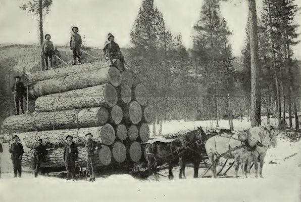
In the Lumber Country
Agricultural pursuits are confined to
the valley of the Clark's Fork and along the tributary streams
that flow into it, such as Thompson River and Prospect and
Vermilion creeks. The bottom lands are of a deep sandy loam,
while a gravelly loam predominates on the bench lands. In the
western half of the county the land is either cut-over land or
natural meadow, and almost all of it is irrigable by private
projects. Near Thompson Falls, 3,000 acres in one tract are
irrigated from the Thompson River. This section of the county is
admirably adapted to dairying, clover and other forage crops
growing in abundance, while the vast area of national forest
reserve furnishes cheap pasturage. Wheat, clover, timothy, oats,
potatoes, peas and barley are the principal crops, although many
experimenters have had success with fruit-growing, especially in
the main valley, where apples, plums, cherries, pears,
strawberries and some peaches have been raised in marketable
quantities. While the development of mining as an industry in
Sanders County has not been carried much beyond the prospecting
stage, it is known that there are quantities of silver, lead,
zinc, copper and gold, particularly in the mineral districts of
the Coeur d'Alenes.
The land area of Sanders County is
2,837 acres, which brings it under the general average of the
fifty-four Montana counties, and it is about tenth smallest in
population, which, according to United States Census report of
1920, is 3,949 souls. The mean temperature of the county is in
the neighborhood of 45.2, and the growing season is from n to
132 days. Lands in the cutover region sell at from $10 to $15 an
acre, and in the prairie sections the price ranges from $20 to
$100 an acre.
The educational system of Sanders is
well organized and of a high order, and in addition to the rural
and graded schools of the county, there are three high schools,
those at Thompson Falls and Plains being accredited to the
four-year term and that at Paradise for a two-year term. Sanders
County, as before noted, can compete with any section of the
country as an outdoor land. Numerous well-stocked trout streams,
wide areas of virgin forests inhabited by deer, elk, cougar,
bear, wildcats, mountain lions, bighorn and mountain goats offer
the best of hunting and fishing, and camp sites at beautiful
mountain lakes are easily accessible by national forest trails.
Hot springs, twenty miles from Perma, on the Northern Pacific,
and located on the former Flathead Indian reservation, is noted
for its medicinal waters and mud baths. The springs, located
midway between the towns of Camas and Hot Springs, have been
leased by the Department of the Interior to a company which is
developing them as a health and pleasure resort, the lease
including more than ioo acres. Plans made by the leasing company
included the building of an electric line connecting the springs
with the railroad and extending beyond the springs about forty
miles. The mud baths have gained something more than a local
reputation as a cure for rheumatism, and unlike the great
majority of baths of this kind throw out hot mud which runs away
with the water. The waters of Hot Springs, which are available
throughout the year, have been found beneficial in the treatment
of venereal diseases and intestinal troubles.
Thompson
Falls
Thompson Falls, the county seat of
Sanders County, is a town of 508 people, according to the 1920
United. States Census report, and is advantageously located on
the Northern Pacific and Clark's Fork, 102 miles northwest of
Missoula, and in the geographical center of the county. It is a
thriving little community, with a good waterworks system, and is
in the heart of the mining and lumbering districts. It maintains
two banking institutions, two weekly newspapers, a good hotel
and a number of retail establishments, in addition to having a
graded and a high school and several churches.
Four miles east of the Thompson
River, on which Thompson Falls is situated, is located an
irrigation project. The Montana Power Company has made a big
hydroelectric installation at Thompson Falls, the power being
used to supply the Chicago, Milwaukee & St. Paul Railroad.
Plains, in the productive Plains Valley, is the outlet for a
large portion of the former Flathead reservation region, and the
center of a big livestock country, in addition to which some of
the finest farms of the county are adjacent to this town. Plains
is also noted as having the longest' bridge in the state of
Montana, crossing the Clark's Fork. Paradise, situated southeast
of Plains, is a division point of the Northern Pacific. Perma
and Dixon are agricultural centers in the eastern end of the
county, and Heron, Noxon, Trout Creek, Whitepine, Alger and
Belknap in the western end.
Montana Counties 1921
Return to
Montana AHGP

Source: Montana its Story and Biography,
by Tom Strout, Volume 1, The American Historical Society, 1921
|