Powell County, Montana 1921
Powell County lies on the western
slope of the main range of the Rocky Mountains in Western
Montana, about midway between the northern and southern
boundaries of the state. It was created January 31, 1901, and
has an area of 2,329 square miles. Most of the surface is
mountainous, but there is quite an amount of good farming land
in the Deer Lodge Valley around Deer Lodge, and also in the Big
Blackfoot Valley around Ovando. Lesser agricultural areas are
found all along the streams. The soil in the Deer Lodge Valley
varies from a rich black loam to a light chocolate, and is
underlaid by a gravelly sub-soil which in places appears on the
surface.
Powell County in General
The county is well watered by several
important streams, which are fed by numerous mountain
tributaries. The Deer Lodge River flows northerly and then
westerly through the southern half, the Big Blackfoot River
westerly, and the Little Blackfoot River and Nevada Creek in a
southerly direction through the northern half of the county. The
south fork of the Flathead River has its source among the high
mountains in the remote northern end of the county and flows
northerly.
Of the 1,621,360 acres contained
within the area of Powell County, 626,209 are included within
national forests, divided as follows: 169,765 acres in the
Missoula Forest, 70,930 acres in the Deer Lodge Forest, 271,000
in the Flathead Forest and 114,514 in the Helena Forest.
Agricultural land values are determined by the location,
altitude, markets and crop adaptability, and vary from $20 to
$150 an acre. Alfalfa and wild hay are the principal crops, but
wheat, oats, barley and flax are also raised, as well as dairy
products, poultry, swine and vegetables, the last four named
products finding a ready market at Butte and Anaconda. The
valleys in the northern half of the county are chiefly devoted
to hay to furnish winter forage for the livestock.
Mining has been developed in the
southern half of the county, the principal mining districts
lying near Elliston on the Little Blackfoot and on Nevada Creek
near Ophir. There has also been some mining near Deer Lodge.
Silver, lead and gold are the chief minerals developed. The
mineral possibilities of the northern half of the county have
not yet been ascertained, as little prospecting has been done
there. That mountainous region, with its good hunting and
fishing, has strong attractions for tourists, especially those
of sporting proclivities, and at Ovando may be found experienced
guides ready to take parties into the primitive.
A Little History
Deer Lodge Valley, along the river by
that name, Deer Lodge, the county seat, and other names and
features of the region, are forcible reminders of the days of
Indian occupancy and lore. It is said by Granville Stuart that
the name Deer Lodge is derived from the Hot Spring mound in the
northern part of what is now Deer Lodge County - the mother of
Powell, Silver Bow and Granite counties. The Butte mentioned, in
the upper part of the valley, was called by the Snake Indians
the Whitetail Deer Lodge, from the fact that the variety of deer
mentioned were very abundant in that region, and that the steam
arising from the mound resembled smoke issuing from a native
lodge.
The settlement of what is now Powell
County was an outcome of the discovery of gold at Gold Creek by
a party led by the Stuarts, in 1858. Though unable at the time
to develop the placer, they returned and began work in 1862. The
news of their discovery led to the founding of Bannack and
Virginia City, and the eventual settlement of Western Montana.
City of Deer
Lodge
Deer Lodge, the county seat, is in
the center of the valley, and contains about one-half of the
total population of the county, which amounts to 6,909 according
to the 1920 census. It is a little city of beautiful homes,
substantial business houses and such modern municipal utilities
as a gravity water system, the source of which is in the
mountains to the east, electric lights and park improvements. In
several sections of the city, the "lodge" idea has been brought
out in a way which is most artistic and sylvan. In that respect,
Deer Lodge town is among the unique communities of Montana, if
not of the states. Its setting is majestic and charming,
situated, as it is, between the main range of the Rocky
Mountains in the east and a spur of the main range on the west,
at the foot of Mount Powell, one of the loftiest of Montana's
peaks.
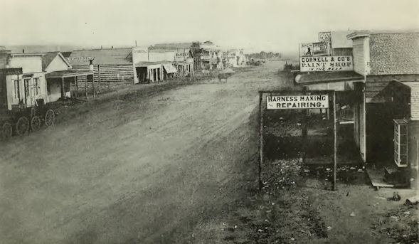
Deer Lodge in 1860
The altitude of the city is about
4,500 feet above sea level, and is surrounded by mountains, with
gentle valleys and broad benches rising from the Deer Lodge
River to the adjacent heights. When the town was originally
platted by the pioneers from the East, it was designed that Deer
Lodge should become a city of homes, and at an early day trees
were planted along the streets and in the surrounding districts.
That policy was also in line with the prevailing ambition of the
earlier days to bring the territorial capital to Deer Lodge.
Albeit that ambition was not realized, the result has been to
make Deer Lodge one of the most delightful shaded cities in
Montana.
Surrounding Deer Lodge are some of
the largest ranches in Montana, as well as numerous farms
productive of wheat, oats, barley and flax.
It is within an hour's ride of Butte
and Anaconda, and the great mining district of the state, and,
as its transportation facilities are good, is one of the large
shipping points of the state. The southern part of Powell County
is traversed by the main lines of the Northern Pacific and the
Chicago, Milwaukee & St. Paul railroads, and the Milwaukee road
has made surveys for another line through the northern part,
between Great Falls and Missoula. The principal automobile
highways running east and west also pass through the county and
are kept in unusually good condition. The main roads fork at
Garrison, one branch going to Butte and the other to Helena.
A few years ago Deer Lodge was made a
division point on the Milwaukee road, since which time it has
developed considerably. It has become a railroad town of some
importance, the company's shops furnishing employment to a
considerable number of men.
Montana State Prison
The Montana State Prison was located
at Deer Lodge twenty-four years ago, and is an imposing pile of
buildings. The records show that there are about 600 prisoners,
but as the system of parole and employment on state buildings
and public highways is in force, at times more than a half have
spent various periods in valuable labor outside the prison
walls. Among the buildings thus erected by prison labor have
been the office of the prison; men's and women's dormitories at
the State Hospital for the Insane at Warm Springs, Deer Lodge
County, and the dairy barn and power house, the State
Tuberculosis Sanitarium at Galen, same county. As a very small
percentage of those paroled is reported as having violated their
privileges, the system (in view of its financial returns)
appears to have been a success.
Deer Lodge furnishes good educational
facilities in thoroughly organized graded schools and the county
high school which, in addition to the regular curriculum,
provides a course in agriculture under the provisions of the
Smith-Hughes act; also, the St. Mary's (Catholic) Academy is
well conducted.
Other towns, besides those mentioned,
are Elliston, on the Little Blackfoot, a mining center, Ovando
and Helmville. The last named is the principal town in the
northern part of the county.
Montana Counties 1921
Return to
Montana AHGP

Source: Montana its Story and Biography,
by Tom Strout, Volume 1, The American Historical Society, 1921
|